The World Chronice of Schedel is really a fascinating book. The Latin version is available online, from the Deutsche Forschungs Gemeinschaft, with the help of the Munich Digitalization Center and the Bavarian State Library.
Here for example is the city of Regensburg, were Albrecht Altdorfer worked as a painter and city head of construction (Baumeister). Or the two-page world map (missing the Euphrates and Tigris ...).
And the German translation of the Schedel'sche Weltchronik is available on Google books.
Showing posts with label map. Show all posts
Showing posts with label map. Show all posts
Saturday, November 2, 2019


Thursday, May 29, 2014
Placing the first Palmyra Smith house
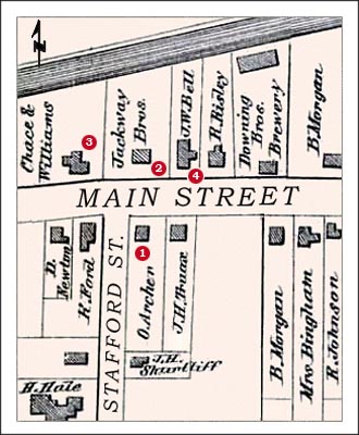
Based on the map published in Plewe et al (2012), pp.16f, I had estimated that the first Smith house in Palmyra, where they lived from 1816-1818 (cf. Pomeroy Tucker (1867), p.12), must have been at the intersection of Stafford Street and Main Street in Western Palmyra.
It looks like "Uncle" Dale R. Broadhurst (of OliverCowdery.com and SidneyRigdon.com fame) came to the same conclusion, and in his transcription of the Palmyra guide books, specifically Thomas L. Cook's Palmyra and Vicinity from 1930 found here, Dale took the Wayne County Atlas page for Palmyra from 1874, published by D.G. Beers & Co, penciled in some houses described in the text plus the Smith house, added (in modern fonts) the street names---Stafford and Main---and pasted the resulting image into the transcription.
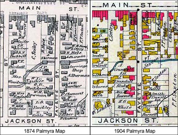
Notice that there are other maps in Uncle Dale's transcription as well, using the Palmyra map from 1874 and another one from 1904; consider the Fayette example and compare 1874 with 1904.
It looks like "Uncle" Dale R. Broadhurst (of OliverCowdery.com and SidneyRigdon.com fame) came to the same conclusion, and in his transcription of the Palmyra guide books, specifically Thomas L. Cook's Palmyra and Vicinity from 1930 found here, Dale took the Wayne County Atlas page for Palmyra from 1874, published by D.G. Beers & Co, penciled in some houses described in the text plus the Smith house, added (in modern fonts) the street names---Stafford and Main---and pasted the resulting image into the transcription.
Notice that there are other maps in Uncle Dale's transcription as well, using the Palmyra map from 1874 and another one from 1904; consider the Fayette example and compare 1874 with 1904.
Tuesday, May 13, 2014
Views of Historical Palmyra
I have been thinking that it might be better to understand how Joseph Smith's Zion was to be understood if one had a clearer idea of what Palmyra Village, in Wayne County, NY, looked like during the time that Joseph Smith Jr was there. The majority of the maps that people of the LDS are interested in is the sites of the various Mormon way points, such as where the Book of Mormon was printed, or where the tavern of Joseph Smith Sr was located, such as the map originally from here:

So they give very little detail about the other houses, the structure of downtown, etc. at least partially because they have to fit Martin Harris' farm in the North and the Hill of Cumorah in the South into the representation as well. (Notice that given the completion of the Erie Canal up to Palmyra, which occurred in 1825, and the continuation of the canal beyond that point, the map cannot really be considered from 1820; rather it is an amalgamated view, temporally.)
There are modern depictions of Palmyra with historical sites drawn in, such as the following two maps (originally from here and here):


These maps work the amalgamation backward, but the "old parts" in the canal, and the change bridge and similar features, often post-date the Mormon era in Palmyra. Ditto for the famous four-church corner, of which only the Presbyterian church, built in 1832, dates from before the Mormon departure. Thus, they can again not be used to enlighten us about the way Palmyra looked when Smith Jr was there.
Now there is a historical atlas of Wayne County from 1874, which has a nice view of Palmyra, but its maps are sold by the Historical Map Company (here). That atlas is also available in the New York Public Library (here), but the prices are even steeper. That's about 40 years too late, in some sense, but it gives a better idea of the way the city was actually used.
And so the quest continues; maybe the friends on Quora have an idea.
Update: Quora pointed me to the maps in Daniel Burr's 1829 Atlas for New York, which contains Wayne county, among others (but already with the Erie Canal), and additional maps from the 1850s and 1870s for the specific area of upstate New York, on (surprise!) one of Dale Broadhurst's Mormon info websites.
While some of these maps can be purchased at the NYPL or at other institutions, the Old Map company is more affordable. Some of the atlases though, such as the Anderson one from 1800, are easy to locate with World Cat, but difficult to travel to (mostly fancy east coast universities).
So they give very little detail about the other houses, the structure of downtown, etc. at least partially because they have to fit Martin Harris' farm in the North and the Hill of Cumorah in the South into the representation as well. (Notice that given the completion of the Erie Canal up to Palmyra, which occurred in 1825, and the continuation of the canal beyond that point, the map cannot really be considered from 1820; rather it is an amalgamated view, temporally.)
There are modern depictions of Palmyra with historical sites drawn in, such as the following two maps (originally from here and here):

and

These maps work the amalgamation backward, but the "old parts" in the canal, and the change bridge and similar features, often post-date the Mormon era in Palmyra. Ditto for the famous four-church corner, of which only the Presbyterian church, built in 1832, dates from before the Mormon departure. Thus, they can again not be used to enlighten us about the way Palmyra looked when Smith Jr was there.
Now there is a historical atlas of Wayne County from 1874, which has a nice view of Palmyra, but its maps are sold by the Historical Map Company (here). That atlas is also available in the New York Public Library (here), but the prices are even steeper. That's about 40 years too late, in some sense, but it gives a better idea of the way the city was actually used.
And so the quest continues; maybe the friends on Quora have an idea.
Update: Quora pointed me to the maps in Daniel Burr's 1829 Atlas for New York, which contains Wayne county, among others (but already with the Erie Canal), and additional maps from the 1850s and 1870s for the specific area of upstate New York, on (surprise!) one of Dale Broadhurst's Mormon info websites.
While some of these maps can be purchased at the NYPL or at other institutions, the Old Map company is more affordable. Some of the atlases though, such as the Anderson one from 1800, are easy to locate with World Cat, but difficult to travel to (mostly fancy east coast universities).
Friday, May 2, 2014
Some relevant map websites thanks to UT
The Perry Castaneda Library at UT has a meta-website for map hosting sites.
Some nice examples include:
- Here is a great map of the Erie Canal.
- Here are a bunch of maps of Western New York.
- Information and Maps for the Holland Land Company
Subscribe to:
Posts (Atom)